The Hayward fault runs through the heart of Montclair, in the Oakland hills behind Piedmont.
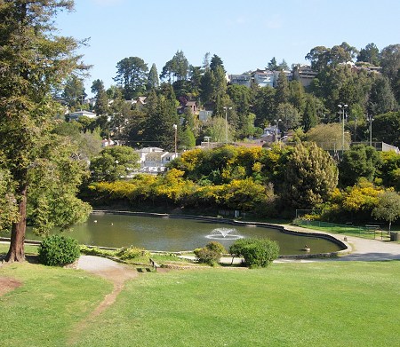
Only in seismologists’ equations, and perhaps deep down in the crust, are faults smooth, flat planes. In the world, on the surface, faults are as ragged and variable as any other geological feature. The Hayward fault is more of a zone, from a few to a hundred meters in width, with several fractures running through it. Where two strands overlap, a block of ground between them may slump in tension or rise in compression, depending on how the strands are oriented. Where the ground slumps, a sag basin may form. Lake Temescal is an example of a sag basin, repurposed as a water feature. So, apparently, is Lake Aliso, the pond on the grounds of Mills College. Montclair Park’s duck pond, as it happens, is in a basin created during railroad construction, so contrary to popular opinion (including my own, until I checked the literature) it’s not a sag basin.
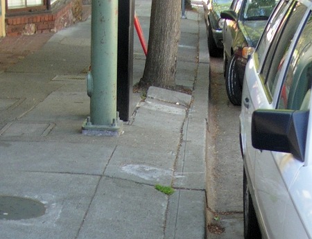
The first “great San Francisco earthquake” occurred 21 October 1868 on the Hayward fault. The epicenter appears to have been in southern San Leandro, and surface rupture extended from there all the way down to Fremont. In Montclair, the other direction along the fault, there was plenty of shaking of course. A trenching study, conducted along the third-base line of the little ballfield in Montclair Park, found no sign of movement along the fault there since the 1868 earthquake. But slow, silent motion does affect the fault in Montclair. The old fire station on Moraga Avenue has been rendered useless by aseismic creep, and some of the houses along the fault appear to show foundation disruption. But generally creep is invisible unless there is some structure that it affects, like the south curb of Medau Place, below. South of here, the fault crosses Route 13, reaching the other side at the head of Dimond Canyon.

23 April 2008 at 10:11 am
Where can I find a map of the hayward fault overlaid a map of Oakland? I’ve lived a stone’s throw from it my whole life, and I’ve always been curious about exactly where I am in relation to it.
23 April 2008 at 11:29 am
if you download google earth, there’s a great overlay available on it
23 April 2008 at 11:54 am
Michael, the best resource page out there is from the US Geological Survey:
earthquake.usgs.gov/regional/nca/1868/
23 April 2008 at 12:55 pm
I can’t see anything in the lower pic that I wouldn’t attribute to root action or even just old sidewalks in non-seismically active areas, am I missing something in the flat picture that is easier to see in 3D?
24 April 2008 at 4:25 pm
Well, there’s a right-lateral offset of about 8 inches exactly where the fault is mapped, and similar offsets are seen in adjoining streets. Not as noticeable as the offsets in Hayward, but creep in Oakland is only a fraction of what it is in Hayward.
21 December 2009 at 10:00 pm
George Turner, the author of the thoughtful Eclectic Plagiodoxy blog, also visits the Montclair stretch of the fault in this post. Photos of deformed floors in the old Lucky store, too.
25 July 2023 at 10:44 pm
The pond goes back to when the Medau family lived there from about the 1860s to 1900. There are pictures of it from 1898.